India's Geography and Environment for CUET General Aptitude
About 10 min to learn · 75 questions
Geography facts are rarely disputed, yet the questions are easy to get wrong, because two neighbouring facts sound like one: forest cover and forest-and-tree cover, largest by area and largest by share, the provisional census and the final one. This lesson covers physical features and the Himalayan ranges, rivers, climate and the monsoon, soils and crops, forests and protected areas, minerals and energy, states and borders, the 2011 Census and environmental law, with every figure cited and a diagram of the Himalayan ranges.
Treat "largest", "highest" and "most" as unfinished questions until you know the unit. Largest by area and largest by share give different states; forest cover and forest-and-tree cover are different numbers; the southernmost point of the mainland is not the southernmost point of India. Most wrong options are the right answer to a slightly different question.
What does not move is where a thing is, when a law was passed, and which body publishes which report. Every figure below carries its source; hover it to see where it comes from.
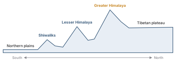
Three parallel ranges. The Shiwaliks are the southernmost, meeting the northern plains; the Lesser Himalaya (Himachal) lies behind them; and the Greater Himalaya (Himadri) holds the highest peaks.
South to north the ranges rise: Shiwaliks, Lesser Himalaya, Greater Himalaya.
Kanniyakumari is the southernmost point of the mainland only; India's southernmost point is in the Nicobar Islands. And Kangchenjunga, not Nanda Devi, is India's highest peak if a shared border peak is allowed; "entirely within India" means Nanda Devi.
By the Indus Waters Treaty of 1960, which gives the Ravi, the Sutlej and the Beas to India; the Indus, the Jhelum and the Chenab to Pakistan. The Indira Gandhi Canal takes water from the Sutlej and Beas at the Harike Barrage into the Thar.
Exam shortcut
The map cannot tell you the split, since all six flow through India. Remember it as: India gets the three that are not the Indus, the Jhelum or the Chenab.
The south-west monsoon sets in over the Kerala coast around the start of June and brings most of India's rain from June to September. Its Bay of Bengal branch drives into the Khasi Hills of Meghalaya, where Mawsynram and Cherrapunji are among the wettest inhabited places on earth. Jaisalmer, in the Thar, gets the least.
It lives off the retreating, north-east monsoon. From October to December the winds blow from land to sea, pick up moisture over the Bay of Bengal, and strike the Coromandel coast when the rest of India is drying out.
Weather
Where
Western disturbances
Winter rain in the north-west, from the Mediterranean
Loo
Hot, dry summer afternoon wind over the northern plains
Mango showers
Pre-monsoon rain in Kerala and coastal Karnataka
Kalbaisakhi
Evening storms of April and May in West Bengal and Assam
High heat with heavy rain, which leaches silica and lime
Cashew, tea, coffee after manuring
Red
Much of the peninsula
Millets and pulses
Watch out
Black soil forms from weathered lava; laterite forms because rain has washed minerals out. A question describing one process and offering the other soil is testing exactly that.
The India State of Forest Report comes from the Forest Survey of India, biennially since 1987. The 2023 report puts 21.76 per cent of the country's area under forest, and 25.17 per cent once tree cover is added. Mangroves are counted separately, at 4,992 sq km.
Ranked by
Leader
Forest area
Madhya Pradesh
Share of the state's area
Lakshadweep, at 91.33 per cent of its area
Example 1 · Which forest figure?
One option says 21.76% of India is forest, another says 25.17%. A question asks for "forest cover". Which is right?
21.76% is forest cover alone.
25.17% adds tree cover outside forests, which the question did not ask for.
Answer
21.76%
Forest type
Where or what
Tropical deciduous
Teak and sal
Mangrove
The Sundarbans
Shola
Nilgiri, Anamalai and Palani hills
India holds parts of four biodiversity hotspots, and the Ganges river dolphin is the national aquatic animal.
The 2021 census was postponed, so 2011 is still the latest complete count: 1.21 billion, or about 121 crore, growth of about 17.7% over 2001, literacy 74.04 per cent, up from 64.83 per cent in 2001, density 382 persons per square kilometre, and sex ratio 943 females per 1,000 males, counted as females per 1,000 males.
Record
State
Most populous
Uttar Pradesh, with about 199 million people
Least populous
Sikkim
Highest sex ratio
Kerala, at 1,084 females per 1,000 males
Highest literacy
Kerala
Lowest literacy, highest density
Bihar
Watch out
The provisional 2011 release gave a sex ratio of 940; the final figure is 943. If both appear, the question is testing whether you know there were two releases.
The Deccan Plateau covers most of peninsular India south of the Satpura range, across several states.
The Chota Nagpur Plateau in the east, the Malwa Plateau in the west and the Meghalaya Plateau in the north-east are all far smaller regions.
The Deccan is bounded by the Western Ghats on one side and the Eastern Ghats on the other, which is why the peninsula's major rivers cross it from west to east.
Which is the highest mountain peak lying entirely within the territory of India?
Show the explanationHide the explanation
AnswerC · Nanda Devi
The question turns on the words 'entirely within', not on height alone.
Kangchenjunga is higher, but it stands on the border between Sikkim and Nepal, so it is not entirely within India.
Mount Everest lies on the Nepal-China border and does not touch India at all; K2 is in the Karakoram, in territory India claims but does not administer.
Nanda Devi, in Uttarakhand, is the highest peak that lies wholly inside India.
Worth noting
Three of the four options are higher than the answer. A question that gives you a superlative always has a second condition attached, and here it is the one doing the work.
Which of these peninsular rivers flows westward and drains into the Arabian Sea?
Show the explanationHide the explanation
AnswerB · The Narmada
The Deccan Plateau slopes from west to east, so almost every large peninsular river runs east into the Bay of Bengal.
The Narmada is one of the exceptions. It flows west through a rift valley between the Vindhya and Satpura ranges and meets the Arabian Sea in Gujarat.
The Godavari, the Krishna and the Mahanadi all follow the general slope and reach the Bay of Bengal.
Worth noting
The Tapi is the other well-known westward-flowing peninsular river, and for the same reason: it too runs along a rift valley rather than down the regional slope.
At Devprayag the Ganga is formed by the meeting of the Bhagirathi and
Show the explanationHide the explanation
AnswerB · the Alaknanda
The Bhagirathi, rising at Gangotri, and the Alaknanda, rising near Badrinath, meet at Devprayag in Uttarakhand; below that point the river is called the Ganga.
The Mandakini joins the Alaknanda earlier, at Rudraprayag.
Zaid crops such as watermelon, muskmelon and cucumber are grown
Show the explanationHide the explanation
AnswerA · in the short summer season between the rabi harvest and the kharif sowing
India has two main cropping seasons: kharif in the monsoon and rabi in winter.
Zaid is the short season between them, roughly March to June, used on irrigated land for fast-growing crops such as melons, cucumbers, vegetables and fodder.
Which of these is inscribed on the UNESCO World Heritage List as a natural site?
Show the explanationHide the explanation
AnswerB · Nanda Devi and Valley of Flowers National Parks
Nanda Devi National Park was inscribed in 1988 and the Valley of Flowers was added as an extension in 2005.
The two are listed together as a single World Heritage property in Uttarakhand.
Kaziranga, Manas, Keoladeo, the Sundarbans and the Western Ghats are India's other natural World Heritage properties.
Worth noting
World Heritage listing is separate from national park status: many national parks are not listed, and listing by itself adds no protection under Indian law.
How does the Census of India express the sex ratio?
Show the explanationHide the explanation
AnswerB · Females per 1,000 males
The Census of India defines the sex ratio as the number of females per 1,000 males.
The figure in the final Primary Census Abstract for 2011 was 943.
Several other countries use the opposite convention, which is why the definition has to be stated rather than assumed.
Worth noting
The provisional release of the same census put it at 940. Which of the two sets a number comes from is worth saying out loud, because both are Census 2011.
The Forest Rights Act, which recognises the rights of Scheduled Tribes and other traditional forest dwellers over forest land and produce, was passed in
Show the explanationHide the explanation
AnswerC · 2006
The Scheduled Tribes and Other Traditional Forest Dwellers (Recognition of Forest Rights) Act was passed in 2006 and came into force in 2008.
Gram sabhas play the central role in deciding claims under it.
1980 is the Forest (Conservation) Act and 1996 the PESA Act for Scheduled Areas.
The National Biodiversity Authority, set up under the Biological Diversity Act of 2002, has its headquarters in
Show the explanationHide the explanation
AnswerC · Chennai
The National Biodiversity Authority was established in 2003 with its headquarters in Chennai.
It regulates access to India's biological resources and makes sure the benefits are shared, working with State Biodiversity Boards and local Biodiversity Management Committees.
Dehradun is home to the Forest Survey of India and the Wildlife Institute of India, and Kolkata to the Botanical and Zoological Surveys.
The area names are NTA's. The chapters inside them are EduFarming's own division, not NTA's.